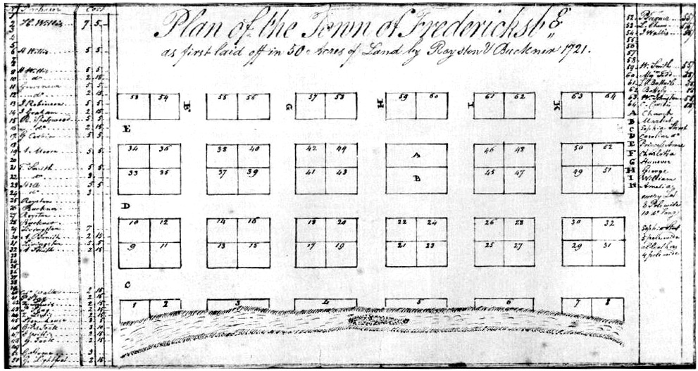
Plan of the Town of Fredericksburg as first laid off in 50 Acres of Land by Royston & Buckner 1721.
The land along the Rappahannock River was uninhabited when this plan was first drawn by Royston and Buckner in 1721. William Livingston and his wife Susannah had leased 50 acres from Royston/Buckner and as of 1726 were operating a small farm...on Lots 27 & 28 on Amelia Street.
On March 8, 1728, a reading was made of a bill to make a town of the Lease Land site. It passed and was signed by the Governor on March 30. The Lease Land was now Fredericksburg.
The story of the founding of Fredericksburg is an interesting one and we are fortunate to have an article written by Trip Wiggins available in our archives with more of it. The snippets paraphrased above are but a taste.
by Trip Wiggins
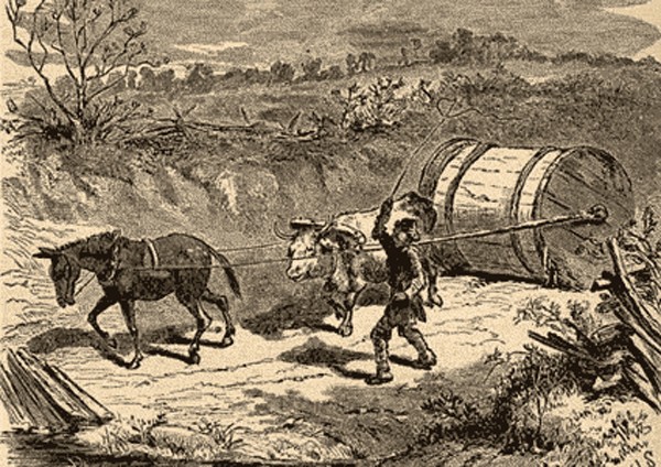
“Rolling a hogshead to Roy’s warehouse”
This month we travel a short distance down river for our Rappahannock area excursion. Virginia was a colony founded in 1607 not as a haven for religious freedom, nor as a penal colony, but rather as an extension of England – a colony set up to make money for the Mother country. A year after its founding at Jamestown, Capt. John Smith set out, in the Discovery, to explore the vastness of the area sailing up the east side of the Chesapeake Bay and returning down the west side while traveling up several of the rivers into the interior of Virginia. One such river was named the Pembroke, in honor of William Herbert, the Third Earl of Pembroke – a large investor in the London Company, the corporation behind the Jamestown experiment. Smith sailed up the river as far as “the falls” before returning.
Four years later trade between whites and the natives was begun by Samuel Argall sailing up the same river – soon to be renamed the “Tappahannock,” then “Rappahannock” which name it still retains to honor the local native inhabitants.
By the mid-17th century ships were routinely plying the waters of the Rappahannock to support the growing number of English colonists who had established plantations in the region. Moving upstream from the Chesapeake, “civilisation” was slowly moving up the river and overtaking the frontier. In the 1650s Col. John Catlett and his half-brother Ralph Rowzee had acquired land in Essex county as far up river as the current location of Port Royal.
Being on the “frontier” meant always facing a potential attack by the now displaced and sometimes hostile Indians and pirates who were still plundering the area’s waterways in the mid-17th century. For this reason several forts were established along the Rappahannock (and the other primary rivers). Catlett was appointed the Colonel of the militia for the fort in the Essex county region and was killed in 1670 while defending the fort against an Indian attack. (In all probability, the “fort” was just the group of armed settlers and not a physical palisade structure.)
By 1675 more and more people destined to lay the foundation of Spotsylvania county and Fredericksburg had appeared on the scene in the Port Royal area patenting thousands of acres. Included in the group were: Lawrence Smith; Robert Taliaferro; Anthony, John, and Richard Buckner; Thomas Royston and Francis Thornton. A key event in the founding of the town was the establishment of the first chartered tobacco warehouse by John Buckner on the site of current Port Royal.
Remember, plantations were established by wealthy land owners not as idyllic settings for homes – but to turn a profit. The largest profit–making crop in the Virginia colony was tobacco – but unless the owners had a way to get their tobacco to buyers it was useless. Virginia was blessed with an abundance of natural highways for transporting tobacco from the plantations to market – rivers. The Potomac (or Patowmack), Rappahannock, York, and James were the “Interstate highways” of their time. All goods going into or out of the colony went via ship. The land had not yet been tamed to build highways very far.
Thus, the founding of a tobacco warehouse was critical in the development of the area. Hogsheads of tobacco could be stored safely out of the elements to await the next ship bound for market. While the large plantations along the river had their own wharves, inland plantations needed a port to get their crop to market. In 1716, John Roy bought Buckner’s warehouse and continued its operation. It ran without much competition until the Conway tobacco inspection warehouse was built in 1734 – twelve miles further upstream in Caroline county.
By now the area was brimming with people. No longer was it a simple frontier tobacco station – but real civilization was creeping in with all the trappings: churches (Church of England, of course, as it was an English colony), shopkeepers, taverns, and families. Additionally “tithes” were being collected by the county government and Crown approved tobacco inspectors were provided housing at the Roy warehouse.
The Roy family, headed by Hugh, first came to Virginia in 1634. Hugh’s son, Richard, settled in King & Queen county and was married about 1679. To this marriage were born at least four children: Hannah, John, William (or Richard Jr.), and James.
Two of these are of interest to us. Hannah, born about 1680, would marry that early leader of Spotsylvania county, Larkin Chew. But for now we will concentrate on the life of John. He was born about 1683. In 1716 he purchased Buckner’s Essex county tobacco warehouse. (Caroline county would not be carved out of Essex for another decade.) John had been an inspector at Buckner’s which was located about 100 yards north (upstream) of the current US 301 bridge. A tobacco inspector was an office of importance in the colonial towns.
About 1712 the Roy and Buckner families became closer as John married Dorothy Buckner Smith – daughter of Richard Buckner. (Richard was John Buckner’s son.) She was also the widow of Charles Smith (of the Lawrence Smith family) and she had blood ties to the Fitzhugh’s of King George Co.
JoJohn and Dorothy had a fairly large and interesting family. Among their children were: Thomas, born about 1712, who managed the warehouse from his father’s death in 1734 until his own death in 1772; Reuben (ca 1715‑1757); Richard (ca 1717‑ca 1795); Mungo; Dorothy; Mary; and Elizabeth. It is to be noted that Elizabeth (Betty) married the future famed Virginia jurist Edmund Pendleton in 1741 but died the same year in childbirth.
John Roy’s wife, Dorothy, deserves special mention in the Roy family annals and in the founding of Port Royal. She is regarded as one of America’s first business women. In a day when men controlled everything and women had few rights, Dorothy was ahead of her time. It was she who is credited with getting a “rolling road” built connecting Chesterfield (west of Bowling Green) to Roy’s warehouse – generally following the current US 301 route. (This was to counter the road between the plantations at Guinea & Francis Conway’s warehouse.) Following the death of her husband in 1734, Dorothy obtained a license and operated a tavern in town, and secured title to both the Roy warehouse and a ferry in her name. She may have been the first woman in Virginia to own a tobacco warehouse. She died in 1746.
ByBy the 1720s the population in the area was growing. More ships were making port visits to the Rappahannock tobacco warehouses and Roy’s warehouse was quickly outpacing Conway’s. In 1727, Lt. Gov. Gooch signed a law creating Caroline county from the upper areas of King and Queen, King William, and Essex counties naming it for King George II’s wife, Caroline of Ansbach. By the 1740s more and more settlers were living around Roy’s warehouse and using the Roy Tavern as a central communications hub for the area (conversation, news, gossip, mail, food & drink, and entertainment). The time was right to form a town. What was still needed was the land on which to lay out the townsite.
That came from Elizabeth Smith, widow of Robert Smith. In September, 1744 she petitioned the House of Burgesses that her husband’s will had ordered 60 acres of land, lying near Roy’s warehouse, be laid off for a town. The same week, Charles Carter, of Cleve, in King George county across the river, requested a town be established near Roy’s warehouse. In those days a bill had to be read before the Council three times before it could be enacted. Oct. 4, 1744, was the third reading for “an Act for establishing a Town near Roy’s warehouse in ye County of Caroline….” It was finally approved by the Governor and his Council on Oct. 25th. The town was born – but it still needed a name. (The 60 acres had been surveyed in 1743 by Robert Brooke who laid out 84 lots on the land east of present-day US 301.)
The “town at Roy’s warehouse” was probably established more for trade and commerce than to provide services to its inhabitants. It had excellent wharves, many blacksmiths, the tobacco warehouses, stables and taverns. It was also located on the main road connecting the capital of Williamsburg with Maryland and important cities to the north (the Potomac ferry crossing was at Hooe’s in modern Dahlgren).
The General Assembly appointed seven trustees and directors to oversee the town: Charles Carter, William Beverley, Thomas Turner, John Baylor, Richard Taliaferro, Lunsford Lomax, and Oliver Towles (the only trustee actually living in Port Royal). Their duties included, “building, carrying on, and maintaining a town on the said land; and they, or any three of them, to have full power to meet as often as they shall think necessary, and shall set apart such land for a market place, a public quay, and appoint such places upon the river for public landings, as they shall think most convenient; and if the same shall be necessary, shall direct the making of wharves and cranes at such public landings, for the public use.”
The first duty was to convey lots to Smith’s widow, Elizabeth, and his sons, as further stipulated in his will. Then they began auctioning off the remaining lots.
Finally a name was settled on – Port Royal – by the General Assembly. Why? Some sources indicate it was in honor of Port Royal, located in Jamaica, West Indies, with whom many Virginia planters had carried on trade. Records from the Revolutionary War indicate that some wanted to change the name to Port Roy as the term “Royal” was in ill favor during the rebellion – but “Royal” remained. Other sources point out that it was named after John Roy and it was merely expanded to Port Royal because it sounded better. Still others say it was named after John’s entrepreneurial wife – Dorothy– who really got the area moving with her road, tavern and tobacco warehouse. What’s the real answer? Perhaps no one will ever know.
Regardless of how it was named, this fascinating town has, for over two and a half centuries, kept its small, port town atmosphere very much alive. Where others have been enlarged – and somewhat trashed by the urban sprawl of progress – Port Royal remains much as it was in John and Dorothy’s day. Come. Drop into the 18th century on your next drive down US 17!
For more, read: Hidden Village, Port Royal, Virginia 1744–1981 by Ralph Hall. Historic Port Royal, Inc. will be reprinting this book in 2001. It is also available at the Central Rappahannock Regional Library.
Reprinted from The Rappahannock Gazette, March/April 2000 edition.